The Pino de la Cruz Recreation Area is a natural enclave of great ecological and social value, located in the public forest of Lucena del Puerto. This space offers visitors and residents an ideal environment for outdoor leisure, socializing, and direct contact with nature.
The area is characterized by a diverse stone pine forest, accompanied by holm oak trees and undergrowth consisting of mastic trees, myrtles, and palm hearts, reflecting its remarkable ecological quality. A small valley crosses the terrain, adding uniqueness to the landscape, although it limits use in areas prone to runoff.
To ensure a comfortable and safe experience, the recreational area has picnic tables and benches, barbecues, a children’s play area, fountains, trash cans, and waste containers.
In addition, it is part of an approximately 3-kilometer pedestrian route that connects the town center of Lucena del Puerto with the recreational area, facilitating access on foot or by bicycle.
Pino de la Cruz is also the main venue for the local pilgrimage known as “El Romerito,” dedicated to the Virgin of El Rocío. The grounds are home to the Casa Hermandad, around which the traditional events of this festival take place, combining religious fervor with popular celebrations.
The Pino de la Cruz Recreational Area is a perfect place to enjoy the nature, culture, and tradition of Lucena del Puerto, offering an enriching experience for all visitors.
The 35-kilometre hiking trail along the Río Tinto Greenway is a unique experience that follows the old railway line between Huelva and the Río Tinto mines.
This unique route, located between the towns of La Palma del Condado and Berrocal in Huelva, stands out for being perfectly integrated into one of the most breathtaking and impressive natural landscapes you can imagine: the Río Tinto. Hikers and cyclists will feel as if they are on Mars, due to the intense red and brown tones of the Río Tinto, caused by the weathering of iron minerals along its course. This route offers walkers a unique experience, combining industrial history, breathtaking natural landscapes and rich biodiversity.
The trail runs through a privileged natural environment, crossing forests of pine, holm oak and cork oak trees, as well as areas of Mediterranean scrub. This diversity of habitats is home to a rich fauna, including various species of birds, mammals and reptiles. In addition, the Tinto River and its surroundings are home to numerous aquatic species and offer opportunities for nature observation.
The route is suitable for both walking and cycling, with adequate signage and designated paths to ensure user safety. However, it is important to bear in mind that some sections may have uneven surfaces or slopes, so caution is recommended, especially in summer due to high temperatures. It is advisable to use the appropriate equipment, and torches are recommended for passing through the two tunnels on the route.
The Corumbel Reservoir, also known as the Lower Corumbel Reservoir, is a hydraulic infrastructure located in the municipality of La Palma del Condado, in the province of Huelva, Andalusia, Spain. Built in 1987, its main function is to store water from the Corumbel stream, near its confluence with the Tinto River, to supply several municipalities in the Condado de Huelva region.
The reservoir covers an area of approximately 400 hectares and has a storage capacity of up to 19 cubic hectometres of water. The dam, which is of the loose material type with a concrete core, reaches a height of 20 metres above the riverbed.
In addition to its main function of supplying water, the area surrounding the reservoir offers natural attractions for visitors and residents. It has recreational areas equipped with children’s playgrounds and barbecues, making it an ideal place for outdoor and family activities. Although it is not navigable, activities such as fishing can be practised in its waters.
Close to the Corumbel Reservoir is the Dehesa La Zorrera, a 360-hectare area of pastureland and mixed woodland where fighting bulls are the main attraction. This area combines nature and Andalusian rural tradition, and is also a meeting point and venue for various events.
The Corumbel Reservoir is, therefore, an enclave that combines functionality and natural beauty, offering both essential water resources and spaces for enjoyment and connection with the environment.
The La Palma del Condado Motorhome Area is an ideal option for those travelling by motorhome and looking for a comfortable and well-located place to park and spend the night.
Located in the La Palma del Condado fairgrounds, this area is approximately 600 metres from the town centre, providing easy access to services such as supermarkets, pharmacies, cash machines, petrol stations and restaurants.
The area has capacity for seven motorhomes and offers essential services for travellers, including drinking water refill points and areas for grey and black water disposal. It is important to note that during the months of August and September, clean water is available at specific times: from 8:00 to 11:00 and from 20:00 to 23:00.
The maximum stay allowed in the area is 72 hours. During the second half of September, coinciding with the Real Feria de La Palma del Condado festival, the area is not operational. During this period, parking is available in the Municipal Sports Centre car park as an alternative for motorhomes.
The La Palma del Condado Motorhome Area offers a combination of essential services and a strategic location, making it an attractive option for travellers exploring the region by motorhome.
The River Tinto is a true symbol of the province of Huelva and, in particular, of the Condado region. Rising in the Sierra de Padre Caro, in the town of Nerva, this river flows for approximately 100 kilometres before emptying into the Huelva estuary, where it joins the River Odiel.
Declared a ‘Protected Landscape’, it has characteristics that make it unique from both a landscape and environmental point of view, due to the acidity of its waters and the very high content of heavy metals and ferruginous salts that give it a range of reddish colours and its peculiar appearance. This unique appearance has also made the river a resource for scientific and photographic tourism.
In addition, this acidity means that there is no classic riverside vegetation on its banks and that its shores have ochre colours that give it an otherworldly appearance. Not surprisingly, its unique characteristics have led NASA to investigate its waters due to their striking resemblance to the planet Mars.
One of the characteristic features of this river are the flour mills, built over several centuries due to the province’s wealth of cereals, which can be found along its entire course. These water mills form part of the historical and industrial heritage of the Condado de Huelva region, where there are up to 23 scattered throughout the municipalities of Paterna del Campo, La Palma del Condado, Villarrasa, Niebla, Moguer and Palos de la Frontera.
Located one kilometre from the town, there is a place known as ‘El Corchito’, which comprises an area set aside for creative use and its surrounding environment. The space has an estimated area of 5 hectares of pine trees.
El Corchito is the site where the local pilgrimage, the popular ‘Romerito’, is held. It is also the place where many of the residents of Bonariegos go to spend their leisure time in direct contact with nature, enjoying the beauty of this beautiful spot.
Some of the Rocío brotherhoods spend the night in this natural paradise on their way to the village of Almonte for the pilgrimage.
Bonares hides surprises that will captivate all your senses.
About ten kilometres from the village and almost next to Doñana is the Arboreto del Villar, where a multitude of eucalyptus species grow, filling the air with their many aromas.
Everything here is sublime, like the purple flowers of the sideroxylon or the trunk of the cinerea. From a botanical point of view, the Arboretum is unrivalled in the whole province, due to the variety and uniqueness of the species that can be seen there.
Created by Gaspar de Lama in 1955, it covers a total of around seventy hectares that were originally associated with agroforestry. Its activity consisted of researching the usefulness of eucalyptus, with eighty plots of land planted with different species of this tree. Characterised by its rapid growth, apart from its usual use for cellulose, the aim was to advance its ornamental and desiccant use.
Now that it has been adapted for this purpose, it can be visited on a pleasant walk lasting approximately one hour.
But it is not all eucalyptus; you can also see a good example of Mediterranean forest, pine forests and abundant wildlife, including birds such as the common nightingale, the bastard nightingale, the warbler and even the Iberian lynx.
The Dehesa Boyal covers 430 hectares of municipal property, 20 of which belong to the San Sebastián Natural Park. This area is notable for its dense forest, consisting mainly of some 1,500 cork oaks, with an average density of 75 trees per hectare. In recent years, this density has been increased through reforestation. There are also eucalyptus trees, holm oaks and areas of cereal crops.
The park is equipped with drinking fountains and picnic areas, and will soon have barbecues. For the more active, there is a training and exercise track, as well as a children’s area with swings and slides. The road access from the municipality is completely paved, making it easy for both residents and visitors to get there.
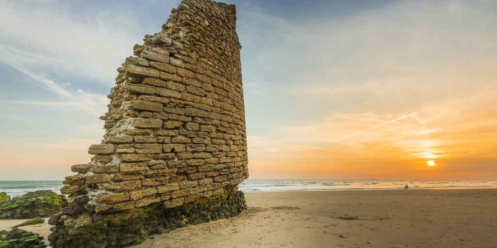
The Torre del Río de Oro, popularly known as the Torre del Loro, is a watchtower declared a Site of Cultural Interest, located on the border between the municipalities of Palos de la Frontera, Almonte, Moguer and Lucena del Puerto. It gives its name to the beach of Torre del Loro. It lies in ruins next to the mouth of a stream, between the Atlantic coast and the foot of the cliff.
The tower was mentioned at the beginning of the 16th century as a powerful watchtower, but a report by Pedro Mateos in 1748 describes the serious damage caused by a storm to the tower’s foundations, threatening to ruin up to a third of them.
In the previous decade, storms had exposed the tower’s foundations, causing alarm, but another storm covered the gap opened by the first, so the alarm was silenced. Both repairs had the technical complication of reinforcing the foundations on the firm ground of a tower located on sand and completely surrounded by the sea at high tide. The solution employed was to create a lining of oyster stone blocks up to a height of seven metres. In 1756, the long-term ruin of the tower was considered inevitable due to its location, surrounded by water and only accessible at low tide. However, the renovations carried out in previous years meant that in 1764 it was observed to be in good condition. In 1827, it was still listed as an active tower in Sebastián Miñano’s Geographical-Statistical Dictionary of Spain and Portugal, although by 1867 it was already listed as in ruins in the coastal charts.
Dehesa del Castillo, also known as Mesa del Castillo, is an archaeological and natural site located north of the municipality of Manzanilla. Various studies have identified this area as the site of the ancient Hispano-Roman city of Ostur, a significant settlement during the Roman period. Archaeological remains found in the area, including urban structures and ceramic materials, provide evidence of the existence of this important urban center.
In addition to its historical significance, Dehesa del Castillo is notable for its ecological value. It is characterized by Mediterranean-style vegetation, predominantly holm oaks and cork oaks, and is home to a rich biodiversity of wildlife, including species such as foxes, wild boars, and various birds of prey. This natural environment offers opportunities for activities such as hiking and birdwatching, allowing visitors to enjoy nature and history in one place.