This route requires moderate effort, which is more than rewarded by the fact that it passes through an area with one of the most interesting histories in the province.
The Tartessians, Turdetani, Romans and Almohads walked these paths before the Reconquista. You can see archaeological remains from the former, provided you request permission from the Provincial Council to visit the end of the route: Tejada la Vieja.
This route is a linear 8.3 km walk of low difficulty that begins in the village of Tejada la Nueva, known for its celebration of the pilgrimage of San Isidro Labrador, and continues along livestock trails such as the Colada del Gamonal and the Cañada del Arrebol. After crossing the bridge over the Tejada stream, the path runs parallel to the riverbed, surrounded by vegetation such as reeds, ash trees and eucalyptus, and fields of wheat and sunflowers. When you cross the road to Aznalcóllar, the terrain becomes more uphill, anticipating the proximity of the mountains.
The route ends at the archaeological site of Tejada la Vieja, a Tartessian-Turdetani settlement from the 8th century BC, located on a flat-topped hill in Escacena del Campo. This site, declared a Site of Cultural Interest, preserves the remains of walls up to four metres high, house foundations and a network of streets. From its highest point, there are panoramic views of the countryside and the mountains, including the hill of La Matanza, associated with a historic battle between Christians and Muslims.
This is one of the easiest and least intense routes in the region. It is barely six kilometres long, with no inclines, and can be considered more of a pleasant stroll than a sporting challenge.
From the village of Tujena, where the Hermitage of San Isidro Labrador is located, take the HU-6108, turning left after one kilometre to take the Berrocal road. Follow this road to reach El Chorrito.
Along the way, you can enjoy a variety of landscapes. At the beginning, there are olive groves where partridges, terreras and little bustards roam freely. Little by little, the landscape changes, accompanied by the Corumbel River in the background. The cultivated fields gradually give way to eucalyptus groves, rockroses, mastic trees, palms and heather. Occasionally, an oak or cork oak tree claims its place in the landscape.
Almost at the end of the route, near the spring, the vegetation becomes more abundant and the smell of brambles and wild roses more intense, if possible. Finally, you reach a water source that flows from the limestone and above it you can see the caves that are characteristic of this enclave.
The San Juan–Niebla Green Gate Route is a 16-kilometre, low-difficulty itinerary connecting the towns of San Juan del Puerto and Niebla, offering visitors a unique experience that combines history, nature and heritage. This route is part of the Green Gates project, an initiative that seeks to promote non-motorised transport, recreation and environmental education, reducing the isolation of urban populations.
The trail begins in San Juan del Puerto, next to the ancient Roman bridge from the 3rd century AD, a structure that stands out for its preservation and beauty. From there, the path follows the route of an old cattle track, the Cordel Camino de Villarrasa a Trigueros, parallel to the A-472 road, until it reaches the Moro stream, where the resting place and watering hole for livestock of the same name is located.
Along the route, walkers and cyclists can enjoy various points of interest, such as the Arroyo Candón stream in the municipality of San Juan del Puerto and the Balastrera bird observatory, a wetland that retains water almost all year round and is home to various species of water birds.
Most of the trail runs alongside the Tinto River, offering panoramic views of this unique landscape. The route passes through gallery forests, marshlands and farmland, providing a diverse environment rich in biodiversity. It is an ideal place for bird watching and photographing natural landscapes.
The route is suitable for both walking and cycling, with adequate signage and designated paths to ensure user safety. In addition, the route is designed to facilitate access for people with reduced mobility, promoting inclusion and enjoyment of the natural environment for all.
The Pinos de la Cruz Route is a 3-kilometer, low-difficulty trail that connects the town of Lucena del Puerto with the Pino de la Cruz recreational area, offering visitors an enriching experience in contact with nature and local heritage.
The route begins on Calle Hernán Cortés and follows a paved road that crosses the Madrona and Valpajoso Public Utility Mountains. The terrain features small elevations with formations of blue marl, clay, sandy silt, and sandstone.
Along the way, walkers can enjoy various points of interest, such as the old fountain “La Sagrada Familia,” surrounded by fruit trees and olive trees. This fountain is an emblematic place that reflects the history and tradition of the municipality. There is also the Pasadera stream, which was navigable in the 18th century and is flanked by reed beds and riverside plants, home to a rich local fauna.
As you continue along the route, the fruit trees give way to a Mediterranean forest of pine, eucalyptus, holm oak, and cork oak trees, with an undergrowth of mastic, myrtle, and palm trees.
The 35-kilometre hiking trail along the Río Tinto Greenway is a unique experience that follows the old railway line between Huelva and the Río Tinto mines.
This unique route, located between the towns of La Palma del Condado and Berrocal in Huelva, stands out for being perfectly integrated into one of the most breathtaking and impressive natural landscapes you can imagine: the Río Tinto. Hikers and cyclists will feel as if they are on Mars, due to the intense red and brown tones of the Río Tinto, caused by the weathering of iron minerals along its course. This route offers walkers a unique experience, combining industrial history, breathtaking natural landscapes and rich biodiversity.
The trail runs through a privileged natural environment, crossing forests of pine, holm oak and cork oak trees, as well as areas of Mediterranean scrub. This diversity of habitats is home to a rich fauna, including various species of birds, mammals and reptiles. In addition, the Tinto River and its surroundings are home to numerous aquatic species and offer opportunities for nature observation.
The route is suitable for both walking and cycling, with adequate signage and designated paths to ensure user safety. However, it is important to bear in mind that some sections may have uneven surfaces or slopes, so caution is recommended, especially in summer due to high temperatures. It is advisable to use the appropriate equipment, and torches are recommended for passing through the two tunnels on the route.
This is perhaps the easiest route in the county. So if you are thinking of going for a walk with family or friends, combining it with entertaining conversation, this may be a good choice. Don’t think that because it is easy it deserves less attention, as it runs through the beautiful countryside of the county of Huelva.
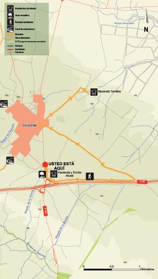
It starts at the esplanade where the pilgrimage of San Isidro Labrador is currently held. Here you will find the chapel of La Divina Pastora or Templo de Alcalá. This building dates back to the late 18th century, although it has undergone several modifications over time. Today it is one of the hallmarks of the municipality.
To begin, take the path that surrounds the Hacienda Alcalá-Alameda. This hacienda, together with the chapel, is the only visible remnant that survives today of the disappeared village of Alcalá de la Alameda, which was depopulated in the 19th century. It consists of two joint haciendas. The current view is of a building, in the style of an Andalusian farmhouse, which still preserves the old 18th-century oil mills. In one of them, the tower of the oil mill still stands, which, as was customary in these rural constructions, was located at one end of the rectangular floor plan.
Once you have passed the estate, continue along the road parallel to the motorway. At km 1.8, turn left onto the road to the port, which leads directly to the town centre. Take care here, as you will have to turn right and drive 50 metres along the A-481. When you reach the intersection with Calle Torralba, turn right again and follow the road that leads to Hacienda Torralba.
The origins of this building date back to the Middle Ages, although it was in the 18th century that it took on its current name. The main building features typical Andalusian architecture and also has details that give an idea of its age, which is difficult to date, such as the watchtower and the pool, both of which are possibly Arab in origin. The different rooms are arranged around a large central courtyard.
This 10 km route of medium difficulty starts at El Corchito and heads towards the Lucena-Bonares road to take the path opposite called Camino del Madroño. A few metres later, it joins the Moguer path, where you should turn right. During this stretch, you will cross an extensive pine forest accompanied by scrubland and pass through a residential area called San Cayetano.
Once you reach the junction with the Vereda del Villar path, also known as Las Payeras, turn left to reach the Arboreto del Villar. Once on the road, you can see beautiful scenery formed by pine and eucalyptus trees and, in the distance, typical crops of the area such as strawberries and raspberries.
During the route, you will cross several streams: La Gragera, La Cañada del Agua and El Arroyo del Avispero. All these streams flow into the Rocina stream, near the Palacio del Acebrón. After crossing the stream, the landscape changes, revealing dry farming crops, as well as the Cortijo del Fraile farmhouse on the right and the Palomera estate on the left.
After passing the Villar stream and a sharp bend lined with centuries-old cork oaks, you will see the arboretum.
This 12 km route is easy and begins where the Rociana-Bonares road starts, crossing the Calancha stream. After 500 metres, leave the hamlet of Calvario behind and turn left towards Mazagón. After crossing the Colmenar stream and leaving behind dry land, cornfields, olive groves and vineyards, you will see an extensive pine forest and eucalyptus grove that will accompany you to the next stream, the Moriana.
At km 6.5, there is a well and an extensive cork oak forest in the area known as La Vaqueriza. Due to its proximity to the Doñana National Park and its characteristics, it is a hunting ground for the Iberian lynx, the most endangered feline in the world.
About 100 metres from the well, across the La Vaqueriza stream, the landscape is populated by ash trees, willows, heather and blackbirds, along with aquatic and edge plants such as reeds, brambles and water plantain.
This 31 km route is easy and starts in Rociana del Condado, passing through places such as El Corchito and the Arboreto del Villar, and returns to Rociana after skirting the Moriana stream.
After setting off, as you pass along the Verilla del Rosal path, you can enjoy amazing views of the Condado. There are also fields, pine trees, eucalyptus trees and olive groves. At the sports centre, you can take a one-kilometre detour to Bonares along the path parallel to the HU-3108.
Continuing along the route, you cross a footbridge to reach El Corchito, a huge pine forest with trees of considerable size. At kilometre 12, you will reach a paved road leading to the Arboreto del Villar, located in Coto de la Matilla.
From Villar, you can go back 500 metres to the intersection with Rociana, take the road on the right and then continue straight on to the Moriana stream. Enjoy the birdsong, some of them birds of prey such as the booted eagle. At this point, of enormous beauty, the landscape begins to change, with dry crops appearing and reigning supreme until you reach Rociana del Condado.
This low-intensity route allows you to take a twelve-kilometre walk while enjoying the typical countryside landscape.
From Almonte, take the A-484 towards Rociana and follow the road parallel to the motorway. Take great care when you need to leave this road to join the motorway, such as at the Almonte exit junction.
Continue left along the Monte Alto road after passing a paved road for about five hundred metres.
However, if you wish to visit Rociana del Condado, which we recommend due to the beauty of its historic centre, take the two-kilometre detour that begins at point 5.6 of the road. Once in Rociana, you can return to the route by retracing your steps to the aforementioned Monte Alto road.
Heading towards Bollullos, the vineyards, which change so much throughout the year, become omnipresent. Crossing the different agricultural areas and fields, we not only get some exercise, but also gain a better understanding of the socio-economic structure of the county, which depends so much on wine, cereals, olives and fruit trees.